PHYSICAL GEOGRAPHY
TROPICAL DRY FORESTS
Tropical dry forests occupy altitudes between 200 and 1,000 meters above sea level. This ecoregion is characterized by average annual temperatures between 20°C and 29°C, average annual precipitation between 60 and 1,600 millimeters, and a dry season that ranges from five to eight months. Its soils are weakly developed from calcareous, metamorphic rocks, and volcanic rocks. The depth and textures of tropical dry forests vary all depending on the nature of underlying bedrock and steep relief occurs over 75 percent of the region.
What makes this ecoregion so valuable is that it is typically rich in flora and fauna, many of which are endemic and threatened. Fiji's tropical dry forests are home to so many species that can only be found in these remote areas of Fiji. The biggest threat to tropical dry forests and its rich flora and fauna species is deforestation as a result of conversion to agricultural land, burning, clear cutting, overgrazing from introduced cattle and goats, and the introduction of destructive and invasive species. Conservation efforts are extremely important for regions like Fiji's tropical dry forests because for many of its endemic species, once they are gone from these areas, they can never be replaced.
What makes this ecoregion so valuable is that it is typically rich in flora and fauna, many of which are endemic and threatened. Fiji's tropical dry forests are home to so many species that can only be found in these remote areas of Fiji. The biggest threat to tropical dry forests and its rich flora and fauna species is deforestation as a result of conversion to agricultural land, burning, clear cutting, overgrazing from introduced cattle and goats, and the introduction of destructive and invasive species. Conservation efforts are extremely important for regions like Fiji's tropical dry forests because for many of its endemic species, once they are gone from these areas, they can never be replaced.
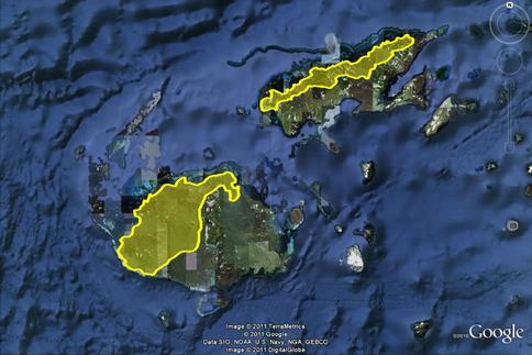
Extent of Fiji Tropical Dry Forest Region on Viti Levu and Vanua Levu
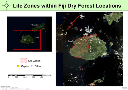
Life zones are geographic region or area defined by its characteristic life forms. Red areas are the life zone of dry forests in Fiji based on annual precipitation and seasonality.
Vanua Levu (top right) & Viti Levu (bottom left). Courtesy of eosnap.com
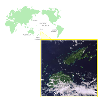
View of the ancient geologic platform that Fiji sits on. Courtesy of Google Maps
CLIMATE
Due to the influence of the surrounding ocean, Fiji has a maritime climate characterized by: mild temperature variations, light to moderate winds, and highly variable rainfall.
Temperature
www.fiji-vacations-resorts.com/images/fiji-rainfall.gif
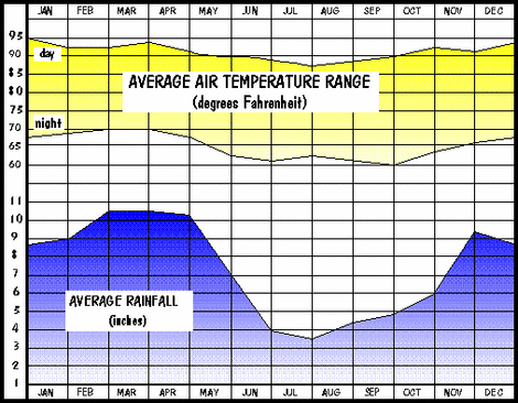
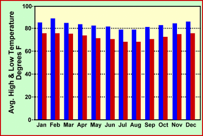
There are only slight variations in daily and seasonal temperatures, with a change of only 2 to 4 °C between the coolest months (July and August) and the warmest months (January to February). While temperatures tend to be uniform at lower elevations, they can differ in the mountainous regions, with day-time temperatures on the leeward side rising by 1 to 2 °C above those on the windward side. This results in cloudy and humid weather in high interior regions of the island. Average night-time temperature can be as low as 18 °C, while day-time temperatures can be as high as 32 °C.
Rainfall
www.fiji-vacations-resorts.com/images/fiji-temperature.gif
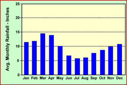
Prevailing south-east trade winds and island topography have the greatest influence on the rainfall in Fiji. Since the south-east trade winds are high in moisture, they create wet climatic zones on the windward sides of the mountains of Viti Levu and Vanua Levu. This orographic precipitation also creates dry climatic zones on the leeward sides of the mountains, resulting in pronounced wet and dry zones on the main islands. The wet zones are in the south-eastern parts of the island, while the dry zones lie in the rain shadow in the north-western sides of the island. Since precipitation is controlled primarily by the movements of the South Pacific Convergence zone, Fiji experiences distinct wet and dry seasons. During the wet season from November to April, annual rainfall ranges from 3000mm around the coast to 6000mm on the mountainous sites, whereas the dry zone averages around 2000 mm. March is usually the wettest month and July is the driest.
Winds
Throughout the year, the predominant winds over Fiji are trade winds from the east to the south-east. While strong winds are uncommon and most likely to occur when trade winds are strongest from June to November, day-time sea breezes blow frequently along the coasts of Viti Levu and Vanua Levu. High winds can also be caused by tropical cyclones that occur during the period of November to April.
Tropical Cyclones, Floods, Droughts
With is location in the South Pacific, Fiji is prone to tropical cyclones which occur with greatest frequency around January and February. The high winds associated with these cyclones can also lead to large-scale flooding via storm tides and heavy swells. Localized flash flooding during the wet season from November to April is also common. Droughts, on the other hand, are dependent on the occurrence of El Ninos. The observed effect of the ENSO in Fiji is below average rainfall that can cause drought in the dry zones of the country.
Back to the Top
Sources
Fiji Meterological Service. http://www.met.gov.fj/climate_fiji.html
UCLA Institute of Environment and Sustainability. http://www.environment.ucla.edu/news/article.asp?parentid=1054
http://www.naia.com.fj/cms/uploads/fiji/content/fiji-climate.gif
UCLA Institute of Environment and Sustainability. http://www.environment.ucla.edu/news/article.asp?parentid=1054
http://www.naia.com.fj/cms/uploads/fiji/content/fiji-climate.gif
